
Thank you for supporting this site ❤️
Make a donation
Make a donation
Negara Ratu topographic map
Click on the map to display elevation.
Thank you for supporting this site ❤️
Make a donation
Make a donation
About this map
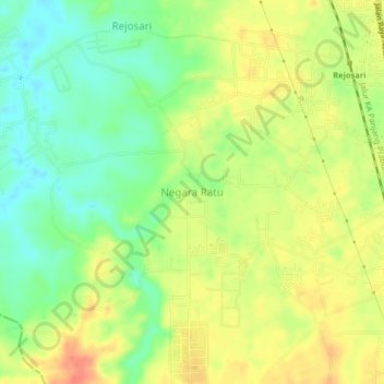
Name: Negara Ratu topographic map, elevation, terrain.
Location: Negara Ratu, Lampung Selatan, Lampung, 35362, Indonesia (-5.32774 105.15131 -5.28774 105.19131)
Average elevation: 100 m
Minimum elevation: 76 m
Maximum elevation: 124 m
Thank you for supporting this site ❤️
Make a donation
Make a donation
Other topographic maps
Click on a map to view its topography, its elevation and its terrain.