
Thank you for supporting this site ❤️
Make a donation
Make a donation
Cefn Coed topographic map
Click on the map to display elevation.
Thank you for supporting this site ❤️
Make a donation
Make a donation
About this map
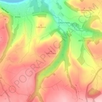
Name: Cefn Coed topographic map, elevation, terrain.
Location: Cefn Coed, Ceredigion, Wales, SA44 6NW, United Kingdom (52.19702 -4.33259 52.19712 -4.33249)
Average elevation: 116 m
Minimum elevation: 0 m
Maximum elevation: 191 m
Thank you for supporting this site ❤️
Make a donation
Make a donation
Other topographic maps
Click on a map to view its topography, its elevation and its terrain.