
Thank you for supporting this site ❤️
Make a donation
Make a donation
Hrishyamukh topographic map
Click on the map to display elevation.
Thank you for supporting this site ❤️
Make a donation
Make a donation
About this map
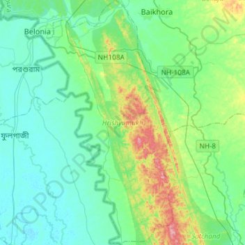
Name: Hrishyamukh topographic map, elevation, terrain.
Location: Hrishyamukh, South Tripura, Tripura, 799156, India (23.05558 91.45278 23.27852 91.59156)
Average elevation: 33 m
Minimum elevation: 4 m
Maximum elevation: 134 m
Thank you for supporting this site ❤️
Make a donation
Make a donation
Other topographic maps
Click on a map to view its topography, its elevation and its terrain.
Thank you for supporting this site ❤️
Make a donation
Make a donation
Thank you for supporting this site ❤️
Make a donation
Make a donation