
Thank you for supporting this site ❤️
Make a donation
Make a donation
Maliit Digos topographic map
Click on the map to display elevation.
Thank you for supporting this site ❤️
Make a donation
Make a donation
About this map
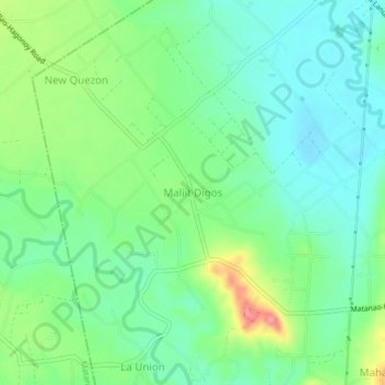
Name: Maliit Digos topographic map, elevation, terrain.
Location: Maliit Digos, Davao del Sur, Davao Region, 8006, Philippines (6.68504 125.23190 6.72504 125.27190)
Average elevation: 45 m
Minimum elevation: 15 m
Maximum elevation: 109 m
Thank you for supporting this site ❤️
Make a donation
Make a donation
Other topographic maps
Click on a map to view its topography, its elevation and its terrain.
Santa Cruz
Santa Cruz is traversed by mountain ranges and high relief that include part of Mount Apo, the highest mountain peak in the Philippines, straddle the south, central, north and north-western portions of the municipality. The rugged topography of the central area gradually undulates toward the coastal plains of…
Average elevation: 360 m
Thank you for supporting this site ❤️
Make a donation
Make a donation