
Thank you for supporting this site ❤️
Make a donation
Make a donation
Agdangan topographic map
Click on the map to display elevation.
Thank you for supporting this site ❤️
Make a donation
Make a donation
About this map
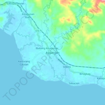
Name: Agdangan topographic map, elevation, terrain.
Location: Agdangan, Quezon, Calabarzon, 4304, Philippines (13.83594 121.87418 13.91594 121.95418)
Average elevation: 18 m
Minimum elevation: -3 m
Maximum elevation: 148 m
Thank you for supporting this site ❤️
Make a donation
Make a donation
Other topographic maps
Click on a map to view its topography, its elevation and its terrain.
Thank you for supporting this site ❤️
Make a donation
Make a donation
Thank you for supporting this site ❤️
Make a donation
Make a donation