
Thank you for supporting this site ❤️
Make a donation
Make a donation
Baltic States topographic map
Click on the map to display elevation.
Thank you for supporting this site ❤️
Make a donation
Make a donation
About this map
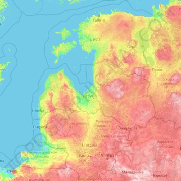
Name: Baltic States topographic map, elevation, terrain.
Location: Baltic States, Latvia (53.89679 20.60099 59.98127 28.24149)
Average elevation: 65 m
Minimum elevation: -4 m
Maximum elevation: 327 m
Thank you for supporting this site ❤️
Make a donation
Make a donation
Other topographic maps
Click on a map to view its topography, its elevation and its terrain.