
Thank you for supporting this site ❤️
Make a donation
Make a donation
York topographic map
Click on the map to display elevation.
Thank you for supporting this site ❤️
Make a donation
Make a donation
About this map
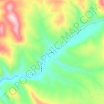
Name: York topographic map, elevation, terrain.
Location: York, Lewis and Clark County, Montana, United States (46.70160 -111.77193 46.74160 -111.73193)
Average elevation: 1,348 m
Minimum elevation: 1,170 m
Maximum elevation: 1,617 m
Thank you for supporting this site ❤️
Make a donation
Make a donation
Other topographic maps
Click on a map to view its topography, its elevation and its terrain.