
Aglasterhausen topographic map
Interactive map
Click on the map to display elevation.
About this map
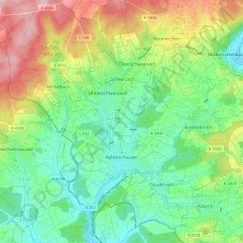
Name: Aglasterhausen topographic map, elevation, terrain.
Average elevation: 261 m
Minimum elevation: 181 m
Maximum elevation: 405 m
Other topographic maps
Click on a map to view its topography, its elevation and its terrain.
Katzenbuckel
Deutschland > Baden-Württemberg > Neckar-Odenwald-Kreis > Waldbrunn
Katzenbuckel, Waldbrunn, Verwaltungsverband Neckargerach-Waldbrunn, Neckar-Odenwald-Kreis, Baden-Württemberg, 69429, Deutschland
Average elevation: 456 m