
Thank you for supporting this site ❤️
Make a donation
Make a donation
Libernon topographic map
Click on the map to display elevation.
Thank you for supporting this site ❤️
Make a donation
Make a donation
About this map
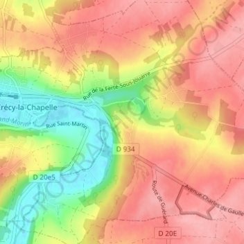
Name: Libernon topographic map, elevation, terrain.
Average elevation: 112 m
Minimum elevation: 48 m
Maximum elevation: 155 m
Thank you for supporting this site ❤️
Make a donation
Make a donation
Other topographic maps
Click on a map to view its topography, its elevation and its terrain.
La Chapelle-sur-Crécy
France > Île-de-France > Seine-et-Marne > Crécy-la-Chapelle
Average elevation: 121 m