
Thank you for supporting this site ❤️
Make a donation
Make a donation
Goldenhill topographic map
Click on the map to display elevation.
Thank you for supporting this site ❤️
Make a donation
Make a donation
About this map
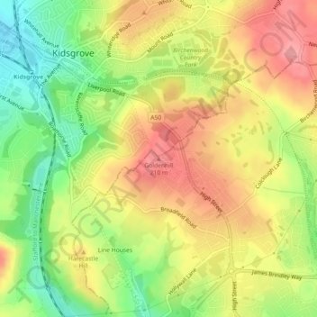
Name: Goldenhill topographic map, elevation, terrain.
Average elevation: 181 m
Minimum elevation: 125 m
Maximum elevation: 228 m
Thank you for supporting this site ❤️
Make a donation
Make a donation
Other topographic maps
Click on a map to view its topography, its elevation and its terrain.
Biddulph Valley Line
United Kingdom > England > Stoke-on-Trent > Hanley > Eaton Park
Average elevation: 138 m
Thank you for supporting this site ❤️
Make a donation
Make a donation