
Trout Lake Township topographic map
Interactive map
Click on the map to display elevation.
About this map
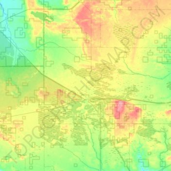
Name: Trout Lake Township topographic map, elevation, terrain.
Average elevation: 254 m
Minimum elevation: 212 m
Maximum elevation: 317 m
Other topographic maps
Click on a map to view its topography, its elevation and its terrain.
Raber Township
United States > Michigan > Chippewa County
Raber Township, Chippewa County, Michigan, 49736, United States
Average elevation: 197 m
Huron Point
United States > Michigan > Chippewa County
Huron Point, Detour Township, Chippewa County, Michigan, United States
Average elevation: 179 m
Drummond Island
United States > Michigan > Chippewa County
Drummond Island, Chippewa County, Michigan, 49726, United States
Average elevation: 181 m
Sugar Island
United States > Michigan > Chippewa County
Sugar Island, Sugar Island Township, Chippewa County, Michigan, United States
Average elevation: 194 m
Whitefish Township
United States > Michigan > Chippewa County
Whitefish Township, Chippewa County, Michigan, United States
Average elevation: 212 m
Kelden
United States > Michigan > Chippewa County > Pickford Township
Kelden, Pickford Township, Chippewa County, Michigan, United States
Average elevation: 184 m
Bay Mills
United States > Michigan > Chippewa County
Bay Mills, Bay Mills Township, Chippewa County, Michigan, 49715, United States
Average elevation: 182 m
Kincheloe
United States > Michigan > Chippewa County
Kincheloe, Kinross Township, Chippewa County, Michigan, 49788, United States
Average elevation: 238 m
Raber
United States > Michigan > Chippewa County
Raber, Raber Township, Chippewa County, Michigan, 49736, United States
Average elevation: 192 m
Rudyard
United States > Michigan > Chippewa County
Rudyard, Rudyard Township, Chippewa County, Michigan, United States
Average elevation: 209 m
Eckerman
United States > Michigan > Chippewa County
Eckerman, Chippewa Township, Chippewa County, Michigan, United States
Average elevation: 244 m
Stalwart
United States > Michigan > Chippewa County
Stalwart, Raber Township, Chippewa County, Michigan, United States
Average elevation: 202 m
Kinross
United States > Michigan > Chippewa County
Kinross, Kinross Township, Chippewa County, Michigan, United States
Average elevation: 224 m
Shelldrake River
United States > Michigan > Chippewa County
Shelldrake River, Whitefish Township, Chippewa County, Michigan, 49767, United States
Average elevation: 195 m
Dafter Township
United States > Michigan > Chippewa County
Dafter Township, Chippewa County, Michigan, United States
Average elevation: 206 m
Superior Township
United States > Michigan > Chippewa County
Superior Township, Chippewa County, Michigan, United States
Average elevation: 219 m
Stirlingville
United States > Michigan > Chippewa County > Pickford Township
Stirlingville, Pickford Township, Chippewa County, Michigan, 49774, United States
Average elevation: 191 m
Goetzville
United States > Michigan > Chippewa County
Goetzville, Raber Township, Chippewa County, Michigan, 49736, United States
Average elevation: 226 m
Strongs
United States > Michigan > Chippewa County
Strongs, Chippewa Township, Chippewa County, Michigan, United States
Average elevation: 262 m
Emerson
United States > Michigan > Chippewa County
Emerson, Whitefish Township, Chippewa County, Michigan, United States
Average elevation: 182 m
Soo Township
United States > Michigan > Chippewa County
Soo Township, Chippewa County, Michigan, 49710, United States
Average elevation: 200 m
Chippewa Township
United States > Michigan > Chippewa County
Chippewa Township, Chippewa County, Michigan, United States
Average elevation: 263 m
Bruce Township
United States > Michigan > Chippewa County
Bruce Township, Chippewa County, Michigan, United States
Average elevation: 197 m
DeTour Village
United States > Michigan > Chippewa County
DeTour Village, Detour Township, Chippewa County, Michigan, United States
Average elevation: 182 m
Raco
United States > Michigan > Chippewa County
Raco, Superior Township, Chippewa County, Michigan, United States
Average elevation: 256 m
Homestead
United States > Michigan > Chippewa County
Homestead, Sugar Island Township, Chippewa County, Michigan, United States
Average elevation: 184 m
Vermilion
United States > Michigan > Chippewa County
Vermilion, Whitefish Township, Chippewa County, Michigan, United States
Average elevation: 188 m
Mission Hill
United States > Michigan > Chippewa County
Mission Hill, Bay Mills Township, Chippewa County, Michigan, United States
Average elevation: 249 m
Lincoln
United States > Michigan > Chippewa County > Drummond Township
Lincoln, Drummond Township, Chippewa County, Michigan, United States
Average elevation: 202 m
Barbeau
United States > Michigan > Chippewa County
Barbeau, Bruce Township, Chippewa County, Michigan, United States
Average elevation: 201 m
Pickford Township
United States > Michigan > Chippewa County
Pickford Township, Chippewa County, Michigan, 49774, United States
Average elevation: 206 m
Detour Township
United States > Michigan > Chippewa County
Detour Township, Chippewa County, Michigan, 49725, United States
Average elevation: 190 m
Drummond Township
United States > Michigan > Chippewa County
Drummond Township, Chippewa County, Michigan, 49726, United States
Average elevation: 181 m
Lake Huron
United States > Michigan > Chippewa County
Lake Huron, Raber Township, Chippewa County, Michigan, United States
Average elevation: 183 m
Cordell
United States > Michigan > Chippewa County > Trout Lake Township
Cordell, Trout Lake Township, Chippewa County, Michigan, United States
Average elevation: 250 m
Sault Ste. Marie
United States > Michigan > Chippewa County
Sault Ste. Marie, Chippewa County, Michigan, 49783, United States
Average elevation: 198 m
Brimley
United States > Michigan > Chippewa County
Brimley, Superior Township, Chippewa County, Michigan, United States
Average elevation: 195 m
Hulbert
United States > Michigan > Chippewa County
Hulbert, Hulbert Township, Chippewa County, Michigan, 49748, United States
Average elevation: 231 m
Paradise
United States > Michigan > Chippewa County
Paradise, Whitefish Township, Chippewa County, Michigan, United States
Average elevation: 190 m
Neebish Island
United States > Michigan > Chippewa County
Neebish Island, Soo Township, Chippewa County, Michigan, 49710, United States
Average elevation: 185 m