
Make a donation
County Kilkenny topographic map
Click on the map to display elevation.
Make a donation
County Kilkenny
The River Nore flows through the county, and the River Suir forms the border with County Waterford. Brandon Hill is the highest point with an elevation of 515 m (1,690 ft). Most of the county has a hilly surface of moderate elevation with uplands in the north-east, the north-west and the South of the county; the middle is lower by comparison.
Make a donation
About this map
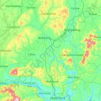
Name: County Kilkenny topographic map, elevation, terrain.
Location: County Kilkenny, Leinster, Ireland (52.24287 -7.67400 52.89394 -6.91456)
Average elevation: 120 m
Minimum elevation: -4 m
Maximum elevation: 784 m
Make a donation
Other topographic maps
Click on a map to view its topography, its elevation and its terrain.
Make a donation
Make a donation
Ferns
Ireland > County Wexford > Ferns
The 19th-century population peaked in 1851, but never reached the levels of medieval times. Lewis's Topography of 1834 claimed the town "consists chiefly of one irregular street, and contains 106 houses indifferently built, retaining no trace of its ancient importance". The Abbey, St.Peter's Church (Catholic…
Average elevation: 60 m
Make a donation
Make a donation