Howth topographic map
Interactive map
Click on the map to display elevation.
About this map
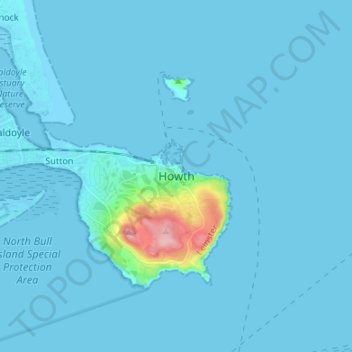
Name: Howth topographic map, elevation, terrain.
Location: Howth, Fingal, Dublin 13, Leinster, D13 T1F3, Ireland (53.34583 -6.10512 53.42583 -6.02512)
Average elevation: 8 m
Minimum elevation: -2 m
Maximum elevation: 160 m
Other topographic maps
Click on a map to view its topography, its elevation and its terrain.
Shannon
The lower Shannon between Killaloe and Limerick had a topography quite different from the long upper reaches. Here the river falls by 30 m (98 ft) in only 20 km (12 mi). William Ockenden, also from England, was placed in charge of works on this stretch in 1757 and spent £12,000 over the next four years,…
Average elevation: 88 m
County Kilkenny
The River Nore flows through the county, and the River Suir forms the border with County Waterford. Brandon Hill is the highest point with an elevation of 515 m (1,690 ft). Most of the county has a hilly surface of moderate elevation with uplands in the north-east, the north-west and the South of the county;…
Average elevation: 120 m
Limerick
Limerick's climate is classified as temperate oceanic (Köppen Cfb). Met Éireann maintains a climatological weather observation station at Shannon Airport, 21 kilometres west-northwest of the city in County Clare. Shannon Airport records an average of 977 millimetres of precipitation annually, most of which…
Average elevation: 45 m
Lambay Island
Lambay Island is the largest island off the east coast of Ireland. It covers about 2.5 km2 (0.97 sq mi). The highest point – a hill known as Knockbane – rises to 126 m (413 ft). The island's high ground lies to the east and aside from Knockbane includes Heath Hill and Tinian Hill, and in the extreme…
Average elevation: 14 m
Ferns
Ireland > County Wexford > Ferns
The 19th-century population peaked in 1851, but never reached the levels of medieval times. Lewis's Topography of 1834 claimed the town "consists chiefly of one irregular street, and contains 106 houses indifferently built, retaining no trace of its ancient importance". The Abbey, St.Peter's Church (Catholic…
Average elevation: 60 m
County Wicklow
The county experiences a narrow annual temperature range. Typical daytime highs range from 17–22 °C (63–72 °F) throughout the county in July and August, with overnight lows in the 11–14 °C (52–57 °F) range, although temperatures in the mountains can be 5–10 °C (41–50 °F) lower. Mean January…
Average elevation: 166 m
Limerick
Limerick's climate is classified as temperate oceanic (Köppen Cfb). Met Éireann maintains a climatological weather station at Shannon Airport, 20 kilometres west of the city in County Clare. Shannon Airport records an average of 977 millimetres of precipitation annually, most of which is rain. Limerick has a…
Average elevation: 10 m