
Make a donation
Lambay Island topographic map
Click on the map to display elevation.
Make a donation
Lambay Island
Lambay Island is the largest island off the east coast of Ireland. It covers about 2.5 km2 (0.97 sq mi). The highest point – a hill known as Knockbane – rises to 126 m (413 ft). The island's high ground lies to the east and aside from Knockbane includes Heath Hill and Tinian Hill, and in the extreme northeast, Pilot's Hill. Steep cliffs lie along the northern, eastern, and southern coasts of the island, while the western side has low-lying land and gentle slopes. Due to the island's topography and exposure to weather, the western shore is where almost all of the island's buildings are located – the Castle, coastguard cottages and guest residences, and the Catholic chapel – as well as the only harbour, while two cottages exist on hillier ground.
Make a donation
About this map
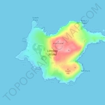
Name: Lambay Island topographic map, elevation, terrain.
Average elevation: 14 m
Minimum elevation: -2 m
Maximum elevation: 119 m
Make a donation
Other topographic maps
Click on a map to view its topography, its elevation and its terrain.