
Brookings County topographic map
Interactive map
Click on the map to display elevation.
Brookings County
Brookings County is on the east side of South Dakota. Its east boundary line abuts the west boundary line of the state of Minnesota. The Big Sioux River flows south-southeastward through the east central part of the county; its point of entry into Moody County marks Brookings County's lowest elevation: 1,568 ft (478 m) ASL.
About this map
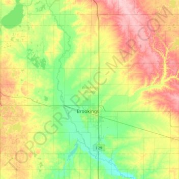
Name: Brookings County topographic map, elevation, terrain.
Location: Brookings County, South Dakota, United States (44.19544 -97.12971 44.54387 -96.45184)
Average elevation: 525 m
Minimum elevation: 472 m
Maximum elevation: 617 m