
Floridablanca topographic map
Interactive map
Click on the map to display elevation.
About this map
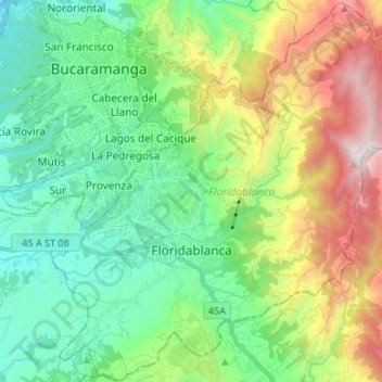
Name: Floridablanca topographic map, elevation, terrain.
Location: Floridablanca, Metropolitana, Santander, Colombia (7.01724 -73.13510 7.14832 -73.00172)
Average elevation: 1,261 m
Minimum elevation: 625 m
Maximum elevation: 2,673 m
Floridablanca (Spanish pronunciation: [floˌɾiðaˈβlaŋka], locally also simply Florida) is a municipality in the department of Santander at an altitude of 925 metres (3,035 ft) in the Eastern Ranges of the Colombian Andes. It is part of the metropolitan area of the departmental capital Bucaramanga. Floridablanca is known for its parks and the Piedra del Sol, a large rock with spirals and circles carved by the Guane over 1,000 years ago. This city is home of the tallest statue of Jesus Christ in Colombia, "El Santisimo". The statue is 40 metres (130 ft) high and weighs 40 tonnes (88,000 lb). The city is situated along the Ruta Nacional 45A, a branch of the Pan American Highway, connecting the capital Bogotá with Santa Marta at the Caribbean coast and Cúcuta as a gateway to Venezuela. Together with other neighboring municipalities of Bucaramanga, Girón and Piedecuesta, Floridablanca is one of the growth areas for the capital of Santander with numerous constructions happening in recent years.
Other topographic maps
Click on a map to view its topography, its elevation and its terrain.
Casita
Colombia > Santander > Concepción
Casita, Concepción, García Rovira, Santander, RAP Gran Santander, Colombia
Average elevation: 3,268 m
Bucaramanga
Colombia > Santander > Bucaramanga
Bucaramanga, Santander, 680005, Colombia
Average elevation: 1,348 m