
Waimarino topographic map
Interactive map
Click on the map to display elevation.
Waimarino
Under the Köppen-Geiger climate classification, National Park has an oceanic climate (Cfb). February is the warmest month, with an average temperature of 14.8 °C, while July is the coldest month with an average temperature of 4.5 °C. Due to an altitude of 822 metres, winters are cold, and generally winter afternoons stay below 10 °C. Frosts are common from May to September, although they can occur during the warmer months. Snow is also a common occurrence in the colder months, sometimes accumulating for several days on end. The summer temperatures are moderate due to the altitude of the village, resulting in cool nights and mild to warm days. The mountains around the village are popular for hiking and mountain biking during the summer. The summer afternoon temperatures often exceed 20 °C, and sometimes reaching 25 °C. The wettest month is July, with 225 mm of precipitation, while February is the driest, with an average of 115 mm, making the climate of National Park lean towards a cool-summer Mediterranean climate (Csb). Overall, the year-round average temperature is 9.6 °C.
About this map
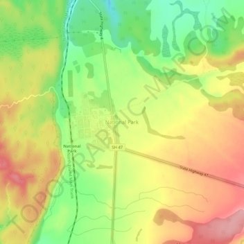
Name: Waimarino topographic map, elevation, terrain.
Average elevation: 815 m
Minimum elevation: 739 m
Maximum elevation: 878 m
Ruapehu District trails, hiking, mountain biking, running and outdoor activities