Geolocate
👉 Easily get elevation data in JSON, GeoTIFF and KML formats using Elevation API
Thank you for supporting this site ❤️
Make a donation

Taculing topographic map

Click on the map to display elevation.

👉 Easily get elevation data in JSON, GeoTIFF and KML formats using Elevation API
Thank you for supporting this site ❤️
Make a donation

About this map

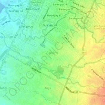
Name: Taculing topographic map, elevation, terrain.

Location: Taculing, Bacolod, Western Visayas, 6100, Philippines (10.62796 122.93296 10.66796 122.97296)

Average elevation: 19 m

Minimum elevation: 0 m

Maximum elevation: 42 m

Other topographic maps

Click on a map to view its topography, its elevation and its terrain.

Taculing

Philippines > Bacolod

Average elevation: 15 m

Barangay 14

Philippines > Bacolod

Average elevation: 7 m