
Mulhouse topographic map
Interactive map
Click on the map to display elevation.
About this map
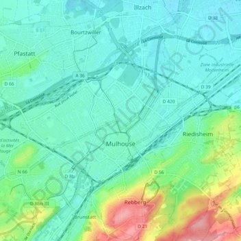
Name: Mulhouse topographic map, elevation, terrain.
Location: Mulhouse, Haut-Rhin, Grand Est, France métropolitaine, France (47.72188 7.28249 47.78337 7.36863)
Average elevation: 254 m
Minimum elevation: 229 m
Maximum elevation: 337 m
La commune de Mulhouse, ville-centre de l'unité urbaine de Mulhouse s'étend sur 22,18 km2 et rassemble 108 312 habitants, soit 44 % de la population de son unité urbaine. Sa densité de population s'élève à 4 885 hab./km2, soit bien plus que celle de la commune de Strasbourg dans le Nord de la région. L'altitude de la commune varie entre 232 mètres et 338 mètres. Au cœur se trouve l'hypercentre (centre-ville) avec une dimension davantage commerciale dans sa partie sud qui correspond à la vieille ville et assurant les fonctions de commandement dans sa partie nord en regroupant notamment les administrations, les tribunaux, la Porte Jeune (centre névralgique de l'agglomération), la cité administrative Coehorn, la mairie, le siège de Mulhouse Alsace Agglomération, des sièges d'entreprises. En s'éloignant de l'hypercentre, on trouve des quartiers à dominante résidentielle comme Dornach, Bourtzwiller ou le Rebberg dont l'habitat plus souvent composé de maisons individuelles, se rapproche davantage des communes composant la banlieue.
Other topographic maps
Click on a map to view its topography, its elevation and its terrain.
Hagenthal-le-Bas
France > Grand Est > Haut-Rhin
Hagenthal-le-Bas, Mulhouse, Haut-Rhin, Grand Est, France métropolitaine, 68220, France
Average elevation: 395 m
Ottmarsheim
France > Grand Est > Haut-Rhin
Ottmarsheim, Mulhouse, Haut-Rhin, Grand Est, France métropolitaine, 68490, France
Average elevation: 224 m
Ampfersbach
France > Grand Est > Haut-Rhin > Stosswihr
Ampfersbach, Stosswihr, Colmar-Ribeauvillé, Haut-Rhin, Grand Est, France métropolitaine, 68140, France
Average elevation: 634 m
Steinbrunn-le-Haut
France > Grand Est > Haut-Rhin
Steinbrunn-le-Haut, Mulhouse, Haut-Rhin, Grand Est, France métropolitaine, 68440, France
Average elevation: 320 m
Volgelsheim
France > Grand Est > Haut-Rhin
Volgelsheim, Colmar-Ribeauvillé, Haut-Rhin, Grand Est, France métropolitaine, 68600, France
Average elevation: 193 m
Sainte-Marie-aux-Mines
France > Grand Est > Haut-Rhin > Sainte-Marie-aux-Mines
Sainte-Marie-aux-Mines, Colmar-Ribeauvillé, Haut-Rhin, Grand Est, France métropolitaine, 68160, France
Average elevation: 713 m
Lapoutroie
France > Grand Est > Haut-Rhin > Lapoutroie
Lapoutroie, Colmar-Ribeauvillé, Haut-Rhin, Grand Est, France métropolitaine, 68650, France
Average elevation: 698 m
Vosges
France > Grand Est > Haut-Rhin > Goldbach-Altenbach
Vosges, Goldbach-Altenbach, Thann-Guebwiller, Haut-Rhin, Grand Est, France métropolitaine, 68760, France
Average elevation: 864 m
Wasserbourg
France > Grand Est > Haut-Rhin > Wasserbourg
Wasserbourg, Colmar-Ribeauvillé, Haut-Rhin, Grand Est, France métropolitaine, 68230, France
Average elevation: 729 m
Katzenthal
France > Grand Est > Haut-Rhin > Katzenthal
Katzenthal, Colmar-Ribeauvillé, Haut-Rhin, Grand Est, France métropolitaine, 68230, France
Average elevation: 293 m
Eschbach-au-Val
France > Grand Est > Haut-Rhin > Eschbach-au-Val
Eschbach-au-Val, Colmar-Ribeauvillé, Haut-Rhin, Grand Est, France métropolitaine, 68140, France
Average elevation: 630 m
Storckensohn
France > Grand Est > Haut-Rhin > Storckensohn
Storckensohn, Thann-Guebwiller, Haut-Rhin, Grand Est, France métropolitaine, 68470, France
Average elevation: 675 m
Sondernach
France > Grand Est > Haut-Rhin > Sondernach
Sondernach, Colmar-Ribeauvillé, Haut-Rhin, Grand Est, France métropolitaine, 68380, France
Average elevation: 931 m
Ribeauvillé
France > Grand Est > Haut-Rhin > Ribeauvillé
Ribeauvillé, Colmar-Ribeauvillé, Haut-Rhin, Grand Est, France métropolitaine, 68150, France
Average elevation: 395 m
Husseren-les-Châteaux
France > Grand Est > Haut-Rhin > Husseren-les-Châteaux
Husseren-les-Châteaux, Colmar-Ribeauvillé, Haut-Rhin, Grand Est, France métropolitaine, 68420, France
Average elevation: 398 m
Masevaux
France > Grand Est > Haut-Rhin > Masevaux-Niederbruck
Masevaux, Masevaux-Niederbruck, Thann-Guebwiller, Haut-Rhin, Grand Est, France métropolitaine, 68290, France
Average elevation: 577 m
Kaysersberg
France > Grand Est > Haut-Rhin > Kaysersberg-Vignoble
Kaysersberg, Kaysersberg-Vignoble, Colmar-Ribeauvillé, Haut-Rhin, Grand Est, France métropolitaine, 68240, France
Average elevation: 523 m
Niedermorschwihr
France > Grand Est > Haut-Rhin
Niedermorschwihr, Colmar-Ribeauvillé, Haut-Rhin, Grand Est, France métropolitaine, 68230, France
Average elevation: 339 m