
Rosengartenspitze topographic map
Interactive map
Click on the map to display elevation.
About this map
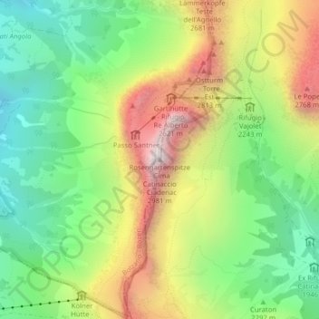
Name: Rosengartenspitze topographic map, elevation, terrain.
Average elevation: 2,236 m
Minimum elevation: 1,734 m
Maximum elevation: 2,952 m
Other topographic maps
Click on a map to view its topography, its elevation and its terrain.
Nigerpass
Italien > Trentino-Südtirol > Bozen > Tiers
Nigerpass, Tiers, Salten-Schlern, Bozen, Trentino-Südtirol, 39050, Italien
Average elevation: 1,652 m