
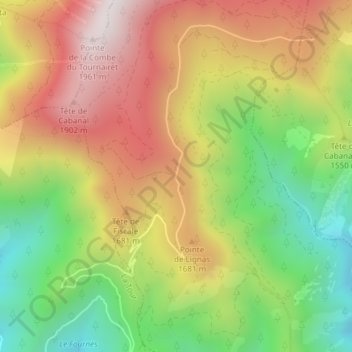
Col d'Andrion topographic map
Interactive map
Click on the map to display elevation.
About this map
Name: Col d'Andrion topographic map, elevation, terrain.
Average elevation: 1,511 m
Minimum elevation: 1,054 m
Maximum elevation: 1,977 m
Other topographic maps
Click on a map to view its topography, its elevation and its terrain.
Riou du Figaret
France > Provence-Alpes-Côte d'Azur > Utelle
Riou du Figaret, Utelle, Nice, Alpes-Maritimes, Provence-Alpes-Côte d'Azur, France métropolitaine, 06450, France
Average elevation: 793 m
Mont Tournairet
France > Provence-Alpes-Côte d'Azur > Utelle
Mont Tournairet, Utelle, Nice, Alpes-Maritimes, Provence-Alpes-Côte d'Azur, France métropolitaine, 06450, France
Average elevation: 1,731 m
Col de Gratteloup
France > Provence-Alpes-Côte d'Azur > Utelle
Col de Gratteloup, GR5, Utelle, Nice, Alpes-Maritimes, Provence-Alpes-Côte d'Azur, France métropolitaine, 06450, France
Average elevation: 1,167 m