
Make a donation
Pulang-Bato topographic map
Click on the map to display elevation.
Make a donation
About this map
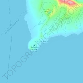
Name: Pulang-Bato topographic map, elevation, terrain.
Location: Pulang-Bato, San Nicolas, Batangas, Calabarzon, Philippines (13.96359 120.96106 14.00359 121.00106)
Average elevation: 22 m
Minimum elevation: 4 m
Maximum elevation: 281 m
Make a donation
Other topographic maps
Click on a map to view its topography, its elevation and its terrain.
Mataasnakahoy
Mataasnakahoy has 16 barangays and its total land area is 22.10 square kilometers (8.53 sq mi). It is bounded by Balete and Lipa City with Taal Lake on its western edge. The town is known for its cool climate due to its high elevation of 379 meters (1,243 ft).
Average elevation: 222 m
Make a donation
Make a donation
Make a donation
Make a donation
Make a donation
Make a donation
Make a donation
Make a donation
Ibaan
Ibaan is located 96 kilometres (60 mi) south of Manila. It is bounded on the northwest by San Jose, the northeast by Lipa City, the east by Rosario, the southeast by Taysan, and the southwest by Batangas City. It has a land area of 68.99 square kilometres (26.64 sq mi) at an altitude of 124 metres (407 ft)…
Average elevation: 126 m
Make a donation
Make a donation
Make a donation
Make a donation