
Make a donation
Bavaria topographic map
Click on the map to display elevation.
Make a donation
Bavaria
At lower elevations the climate is classified according to Köppen's guide as "Cfb" or "Dfb". At higher altitudes the climate becomes "Dfc" and "ET".
Make a donation
About this map
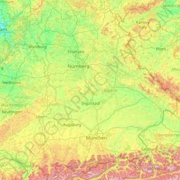
Name: Bavaria topographic map, elevation, terrain.
Location: Bavaria, Germany (47.27011 8.97637 50.56471 13.83965)
Average elevation: 566 m
Minimum elevation: 104 m
Maximum elevation: 2,850 m
Make a donation
Other topographic maps
Click on a map to view its topography, its elevation and its terrain.
Berlin
Berlin straddles the banks of the River Spree, which flows into the River Havel (a tributary of the River Elbe) in the western borough of Spandau. Among the city's main topographical features are the many lakes in the western and southeastern boroughs formed by the Spree, Havel, and Dahme rivers (the largest…
Average elevation: 47 m
Queichhambach
Germany > Rhineland-Palatinate > Landkreis Südliche Weinstraße > Annweiler am Trifels
Average elevation: 255 m
Make a donation
Make a donation
Hochstaufen
Germany > Bavaria > Landkreis Berchtesgadener Land > Bad Reichenhall
At an altitude of 1,750 m is the Reichenhaller Haus, an alpine hut of the Deutscher Alpenverein (Section Bad Reichenhall).
Average elevation: 1,115 m
Marxhagen
Germany > Mecklenburg-Vorpommern > Mecklenburgische Seenplatte > Moltzow
Average elevation: 89 m
Make a donation
Make a donation
Kellmünz an der Iller
Germany > Bavaria > Landkreis Neu-Ulm > Kellmünz a.d.Iller
Average elevation: 562 m
Dettingen
Germany > Baden-Württemberg > Landkreis Tübingen > Rottenburg am Neckar
Average elevation: 464 m
Make a donation
Pegnitz
Germany > Bavaria > Nürnberger Land > Hersbruck > Weiher
The Pegnitz has its source in the town of the same name at an altitude of 425 m (1,394 ft) and meets the Rednitz at 283 m (928 ft) in Fürth to form the Regnitz river. Shortly after the source, the Pegnitz unites with the 15 km (9.3 mi) long Fichtenohe while keeping the name of the shorter tributary. Some…
Average elevation: 357 m
Make a donation
Dessau
Germany > Saxony-Anhalt > Dessau-Roßlau
Dessau is situated on a floodplain where the Mulde flows into the Elbe. This causes yearly floods. The worst flood took place in the year 2002, when the Waldersee district was nearly completely flooded. The south of Dessau touches a well-wooded area called Mosigkauer Heide. The highest elevation is a 110 m…
Average elevation: 62 m
Make a donation
Kessin
Germany > Mecklenburg-Vorpommern > Mecklenburgische Seenplatte > Grapzow
Average elevation: 30 m
Make a donation
Make a donation
Make a donation
Zugspitze
Germany > Bavaria > Landkreis Garmisch-Partenkirchen > Grainau
The mountain rises eleven kilometres southwest of Garmisch-Partenkirchen and just under six kilometres east of Ehrwald. The border between Germany and Austria runs over the west summit; thus the Zugspitze massif belongs to the German state of Bavaria and the Austrian state of Tyrol. The municipalities…
Average elevation: 2,300 m
Eifel
Germany > Rhineland-Palatinate > Landkreis Ahrweiler > Adenau
The Eifel is in the Atlantic climate zone with its relatively high precipitation; winters that are moderately cold and long with periods of snow; and summers that are often humid and cool. The prevailing wind is west/southwest. A relatively dry and milder climate prevails in the wind and rain shadow of the…
Average elevation: 585 m
Make a donation
Roggensee
Germany > Baden-Württemberg > Landkreis Biberach > Bad Schussenried
Average elevation: 661 m
Plettenburg
Germany > North Rhine-Westphalia > Rheinisch-Bergischer Kreis > Wermelskirchen > Grunewald
Average elevation: 231 m
Make a donation