
Thank you for supporting this site ❤️
Make a donation
Make a donation
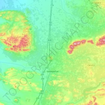
Valdepeñas topographic map
Click on the map to display elevation.
Thank you for supporting this site ❤️
Make a donation
Make a donation
Valdepeñas
El clima de la localidad valdepeñera es un clima mediterráneo continental con inviernos fríos y veranos muy calurosos. Su altitud de 705 m sobre el nivel del mar y su orografía le sumerge dentro de una fuerte oscilación térmica anual, con bajas temperaturas invernales y veranos calurosos.
Thank you for supporting this site ❤️
Make a donation
Make a donation
About this map
Name: Valdepeñas topographic map, elevation, terrain.
Location: Valdepeñas, Ciudad Real, Castilla-La Mancha, 13300, España (38.66991 -3.54927 38.94854 -3.24387)
Average elevation: 730 m
Minimum elevation: 645 m
Maximum elevation: 1,004 m
Thank you for supporting this site ❤️
Make a donation
Make a donation
Other topographic maps
Click on a map to view its topography, its elevation and its terrain.
La Buitrera
España > Castilla-La Mancha > Señorío de Molina > Olmeda de Cobeta
Average elevation: 1,112 m
Thank you for supporting this site ❤️
Make a donation
Make a donation