
Thank you for supporting this site ❤️
Make a donation
Make a donation
Bethells Beach topographic map
Click on the map to display elevation.
Thank you for supporting this site ❤️
Make a donation
Make a donation
About this map
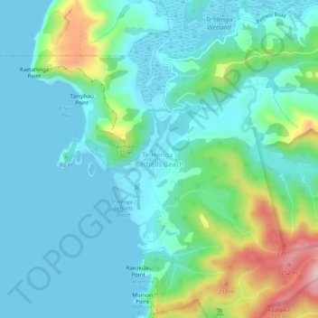
Name: Bethells Beach topographic map, elevation, terrain.
Location: Bethells Beach, Waitakere Ranges, Auckland, New Zealand (-36.90963 174.43029 -36.86963 174.47029)
Average elevation: 57 m
Minimum elevation: 0 m
Maximum elevation: 265 m
Auckland trails, hiking, mountain biking, running and outdoor activities
Thank you for supporting this site ❤️
Make a donation
Make a donation