
Thank you for supporting this site ❤️
Make a donation
Make a donation
Legazpi topographic map
Click on the map to display elevation.
Thank you for supporting this site ❤️
Make a donation
Make a donation
About this map
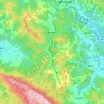
Name: Legazpi topographic map, elevation, terrain.
Average elevation: 548 m
Minimum elevation: 195 m
Maximum elevation: 1,411 m
Thank you for supporting this site ❤️
Make a donation
Make a donation
Other topographic maps
Click on a map to view its topography, its elevation and its terrain.
Soil
Spain > Autonomous Community of the Basque Country > Montaña Alavesa/Arabako Mendialdea
Average elevation: 898 m
Donostia / San Sebastián
Spain > Autonomous Community of the Basque Country > Donostialdea > Donostia / San Sebastián
Average elevation: 134 m