
Thank you for supporting this site ❤️
Make a donation
Make a donation
Limpenhoe topographic map
Click on the map to display elevation.
Thank you for supporting this site ❤️
Make a donation
Make a donation
About this map
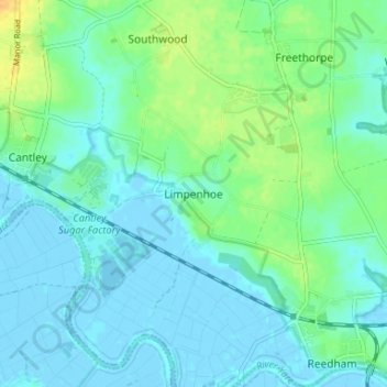
Name: Limpenhoe topographic map, elevation, terrain.
Location: Limpenhoe, Broadland, Norfolk, England, NR13 3LQ, United Kingdom (52.55715 1.52237 52.59715 1.56237)
Average elevation: 7 m
Minimum elevation: -4 m
Maximum elevation: 28 m
Thank you for supporting this site ❤️
Make a donation
Make a donation
Other topographic maps
Click on a map to view its topography, its elevation and its terrain.