
Kraljevo topographic map
Interactive map
Click on the map to display elevation.
About this map
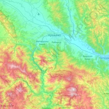
Name: Kraljevo topographic map, elevation, terrain.
Location: Kraljevo, Рашки управни округ, Serbie centrale, Serbie (43.38822 20.32391 43.88136 20.96203)
Average elevation: 611 m
Minimum elevation: 162 m
Maximum elevation: 1,756 m
Other topographic maps
Click on a map to view its topography, its elevation and its terrain.
Плешин
Serbie > Serbie centrale > Рашки управни округ > Општина Рашка
Плешин, Општина Рашка, Рашки управни округ, Serbie centrale, Serbie
Average elevation: 1,241 m
Маглич
Serbie > Serbie centrale > Рашки управни округ > Kraljevo
Маглич, Стаза Маглич-Чикер, Замчање, Kraljevo, Рашки управни округ, Serbie centrale, Serbie
Average elevation: 452 m
Долово
Serbie > Serbie centrale > Рашки управни округ > Општина Тутин
Долово, Општина Тутин, Рашки управни округ, Serbie centrale, Serbie
Average elevation: 1,148 m
Лазац
Serbie > Serbie centrale > Рашки управни округ
Лазац, Рашки управни округ, Serbie centrale, Serbie
Average elevation: 409 m