
Westchester topographic map
Interactive map
Click on the map to display elevation.
About this map
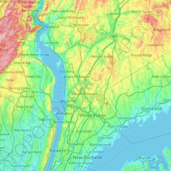
Name: Westchester topographic map, elevation, terrain.
Location: Westchester, New York, United States of America (40.87172 -73.98328 41.36638 -73.48270)
Average elevation: 95 m
Minimum elevation: -1 m
Maximum elevation: 421 m
At 987 feet (301 m), the highest elevation in the county is a U.S. Coast and Geodetic Survey benchmark known as "Bailey" in Mountain Lakes Park near the Connecticut state line. The lowest elevation is sea level, along both the Hudson and Long Island Sound.
Other topographic maps
Click on a map to view its topography, its elevation and its terrain.
Yaphank
United States of America > New York > Yaphank
Yaphank, Suffolk, New York, 11980, United States of America
Average elevation: 24 m
Saratoga County
United States of America > New York
Saratoga County, New York, United States of America
Average elevation: 218 m
Essex County
United States of America > New York
Essex County, New York, United States of America
Average elevation: 418 m
Farmingville
United States of America > New York > Farmingville
Farmingville, Suffolk, New York, 11738, United States of America
Average elevation: 47 m
Honeymoon Island
United States of America > New York
Honeymoon Island, Franklin County, New York, United States of America
Average elevation: 489 m
Riverhead
United States of America > New York > Riverhead
Riverhead, Suffolk County, New York, United States of America
Average elevation: 13 m
Syracuse
United States of America > New York > Syracuse
Syracuse, Onondaga County, New York, United States of America
Average elevation: 172 m
Barrytown
United States of America > New York > Barrytown
Barrytown, Town of Red Hook, Dutchess, New York, 12507, United States of America
Average elevation: 34 m
Sullivan County
United States of America > New York
Sullivan County, New York, United States of America
Average elevation: 435 m
Chenango County
United States of America > New York
Chenango County, New York, United States of America
Average elevation: 442 m
Niagara County
United States of America > New York
Niagara County, New York, United States of America
Average elevation: 137 m
Saint Lawrence County
United States of America > New York
Saint Lawrence County, New York, United States of America
Average elevation: 239 m
Nassau County
United States of America > New York
Nassau County, New York, United States of America
Average elevation: 18 m
Niagara Falls
United States of America > New York > Niagara Falls
Niagara Falls, Niagara County, New York, United States of America
Average elevation: 180 m