
Thank you for supporting this site ❤️
Make a donation
Make a donation
Lagangilang topographic map
Click on the map to display elevation.
Thank you for supporting this site ❤️
Make a donation
Make a donation
About this map
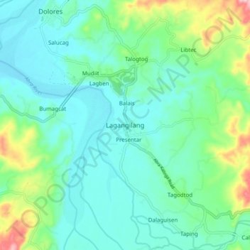
Name: Lagangilang topographic map, elevation, terrain.
Location: Lagangilang, Abra, 2802, Philippines (17.57269 120.69366 17.65269 120.77366)
Average elevation: 103 m
Minimum elevation: 47 m
Maximum elevation: 294 m
Thank you for supporting this site ❤️
Make a donation
Make a donation
Other topographic maps
Click on a map to view its topography, its elevation and its terrain.