
Thank you for supporting this site ❤️
Make a donation
Make a donation
Harichand topographic map
Click on the map to display elevation.
Thank you for supporting this site ❤️
Make a donation
Make a donation
Harichand
Harichand is a town and union council in the Charsadda District of Khyber-Pakhtunkhwa. It is located at 34°23'2"N 71°48'18"E and has an altitude of 381 meters (1253 feet).
Thank you for supporting this site ❤️
Make a donation
Make a donation
About this map
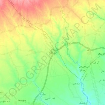
Name: Harichand topographic map, elevation, terrain.
Average elevation: 410 m
Minimum elevation: 369 m
Maximum elevation: 458 m
Thank you for supporting this site ❤️
Make a donation
Make a donation