
Tweed Shire Council topographic map
Interactive map
Click on the map to display elevation.
About this map
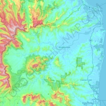
Name: Tweed Shire Council topographic map, elevation, terrain.
Location: Tweed Shire Council, New South Wales, Australia (-28.54273 153.10721 -28.15702 153.58593)
Average elevation: 212 m
Minimum elevation: -3 m
Maximum elevation: 1,178 m
Other topographic maps
Click on a map to view its topography, its elevation and its terrain.
Blue Mountains
A sandstone plateau dominated by a landscape of endless eucalyptus forests, the Blue Mountains are located at the top of a 470-million-year-old quartzite. In the Permian period, a shallow sea covered the region, when rivers brought shales, siltstones and mudstones. Then during the Mesozoic period, rivers…
Average elevation: 566 m