
Thank you for supporting this site ❤️
Make a donation
Make a donation
Strathmoor Manor topographic map
Click on the map to display elevation.
Thank you for supporting this site ❤️
Make a donation
Make a donation
About this map
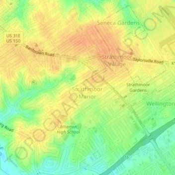
Name: Strathmoor Manor topographic map, elevation, terrain.
Location: Strathmoor Manor, Jefferson County, Kentucky, United States (38.21670 -85.68715 38.22110 -85.68001)
Average elevation: 161 m
Minimum elevation: 138 m
Maximum elevation: 176 m
Thank you for supporting this site ❤️
Make a donation
Make a donation
Other topographic maps
Click on a map to view its topography, its elevation and its terrain.
Jefferson Memorial Forest
United States > Kentucky > Jefferson County > Louisville
Average elevation: 164 m
Louisville-Jefferson County (Balance)
United States > Kentucky > Jefferson County > Louisville
Average elevation: 157 m
Thank you for supporting this site ❤️
Make a donation
Make a donation
Thank you for supporting this site ❤️
Make a donation
Make a donation
Falls of the Ohio State Park
United States > Kentucky > Jefferson County > Louisville
Average elevation: 135 m
Bellewood
United States > Kentucky > Jefferson County > St. Matthews > Bellewood
Average elevation: 167 m