
Totara Lagoon topographic map
Interactive map
Click on the map to display elevation.
About this map
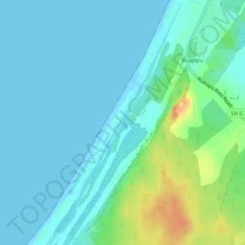
Name: Totara Lagoon topographic map, elevation, terrain.
Average elevation: 10 m
Minimum elevation: -1 m
Maximum elevation: 46 m
Other topographic maps
Click on a map to view its topography, its elevation and its terrain.
Ruatapu
Ruatapu, Westland District, West Coast, 7883, New Zealand
Average elevation: 11 m
Ogilvie Lagoon
Ogilvie Lagoon, Ruatapu Ross Road, Ruatapu, Westland District, West Coast, 7812, New Zealand
Average elevation: 49 m