
Thank you for supporting this site ❤️
Make a donation
Make a donation
Awendo topographic map
Click on the map to display elevation.
Thank you for supporting this site ❤️
Make a donation
Make a donation
About this map
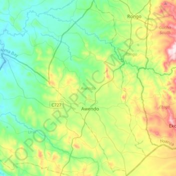
Name: Awendo topographic map, elevation, terrain.
Location: Awendo, Migori County, Nyanza, Kenya (-1.01753 34.46430 -0.73176 34.62226)
Average elevation: 1,435 m
Minimum elevation: 1,252 m
Maximum elevation: 1,876 m
Thank you for supporting this site ❤️
Make a donation
Make a donation
Other topographic maps
Click on a map to view its topography, its elevation and its terrain.