
Paillet topographic map
Interactive map
Click on the map to display elevation.
About this map
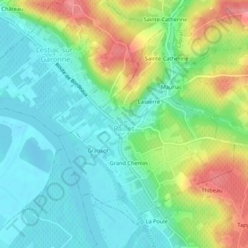
Name: Paillet topographic map, elevation, terrain.
Average elevation: 34 m
Minimum elevation: 1 m
Maximum elevation: 98 m
Other topographic maps
Click on a map to view its topography, its elevation and its terrain.
Les Arnauds
France > Nouvelle-Aquitaine > Gironde > Saint-Ciers-de-Canesse
Les Arnauds, Saint-Ciers-de-Canesse, Blaye, Gironde, Nouvelle-Aquitaine, Metropolitan France, 33710, France
Average elevation: 48 m
Cars
France > Nouvelle-Aquitaine > Gironde
Cars, Blaye, Gironde, Nouvelle-Aquitaine, Metropolitan France, 33390, France
Average elevation: 35 m