
Waverley topographic map
Interactive map
Click on the map to display elevation.
About this map
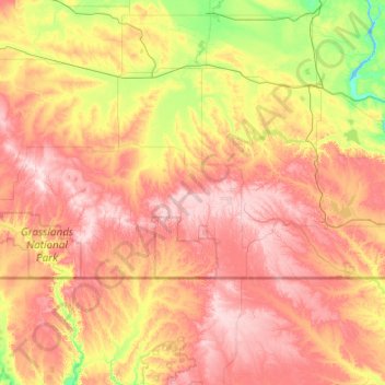
Name: Waverley topographic map, elevation, terrain.
Location: Waverley, Saskatchewan, Canada (48.64130 -107.27960 49.92130 -105.99960)
Average elevation: 820 m
Minimum elevation: 669 m
Maximum elevation: 1,035 m
Other topographic maps
Click on a map to view its topography, its elevation and its terrain.
Regina
Unlike other planned cities in the Canadian West, on its treeless flat plain Regina has few topographical features other than the small spring run-off, Wascana Creek. Early planners took advantage of such opportunity by damming the creek to create a decorative lake to the south of the central business district…
Average elevation: 582 m