
Warkworth topographic map
Interactive map
Click on the map to display elevation.
About this map
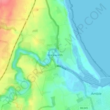
Name: Warkworth topographic map, elevation, terrain.
Average elevation: 20 m
Minimum elevation: -3 m
Maximum elevation: 70 m
Other topographic maps
Click on a map to view its topography, its elevation and its terrain.
Hexham
United Kingdom > England > Northumberland
Hexham, Northumberland, North of Tyne, England, United Kingdom
Average elevation: 122 m
Ninebanks
United Kingdom > England > Northumberland
Ninebanks, West Allen, Northumberland, North of Tyne, England, NE47 8DA, United Kingdom
Average elevation: 341 m