Geolocate

Mole Tops topographic map

Interactive map

Click on the map to display elevation.

About this map

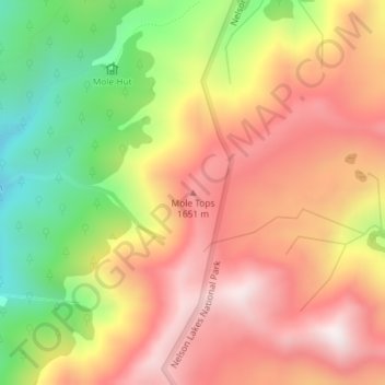
Name: Mole Tops topographic map, elevation, terrain.

Location: Mole Tops, Tasman, New Zealand (-41.97039 172.57929 -41.97029 172.57939)

Average elevation: 1,414 m

Minimum elevation: 978 m

Maximum elevation: 1,761 m

Tasman trails, hiking, mountain biking, running and outdoor activities

Other topographic maps

Click on a map to view its topography, its elevation and its terrain.

Lake Rotoiti

New Zealand > Tasman > Saint Arnaud

Average elevation: 1,031 m

Golden Bay

New Zealand > Tasman > Tasman District

Average elevation: 43 m

Nelson Lakes National Park

New Zealand > Tasman

Average elevation: 1,098 m

Maruia River

New Zealand > Tasman

Average elevation: 760 m

Mārahau River

New Zealand > Tasman > Marahau

Average elevation: 245 m

Tonga Island

New Zealand > Tasman

Average elevation: 9 m

Takaka River

New Zealand > Tasman

Average elevation: 832 m

Onekaka River

New Zealand > Tasman

Average elevation: 55 m