
Peterborough topographic map
Interactive map
Click on the map to display elevation.
Peterborough
Peterborough's topography is largely defined by land formations created by the receding Wisconsian glaciers 10,000–15,000 years ago. The South End and Downtown portions of the city sit on what was the bottom of the glacial Lake Peterborough—part of a glacial spillway created when glacial meltwaters from ancient Lake Algonquin (now Lake Huron) travelled south to ancient Lake Iroquois (now Lake Ontario). This area of relatively low and flat relief (approximately 191–200 m (627–656 ft) above sea level) is prone to flooding, exemplified in the major flood that occurred on July 15, 2004. The ground elevation rises to the west, north, and east where a large upland area (the Peterborough Drumlin field) defines the landscape. Much of the land in the north and west ends of the city rises to 230–274 m (755–899 ft) above sea level, with Tower Hill, at 286 m (938 ft) above sea level, being the highest point. Armour Hill, another prominent drumlin located in east city, forms the physical obstacle that the Trent-Severn Waterway ascends by way of the Peterborough Lift Lock. The Oak Ridges Moraine is located approximately 15 km (9.3 mi) south of the city.
About this map
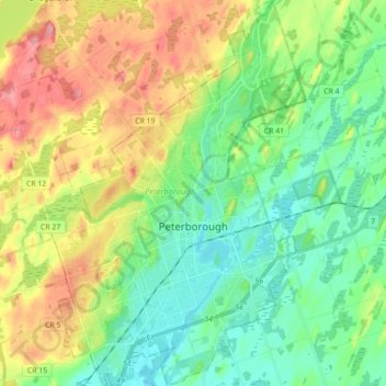
Name: Peterborough topographic map, elevation, terrain.
Location: Peterborough, Central Ontario, Ontario, Canada (44.25263 -78.38797 44.37849 -78.26833)
Average elevation: 235 m
Minimum elevation: 186 m
Maximum elevation: 316 m
Other topographic maps
Click on a map to view its topography, its elevation and its terrain.
Millbrook
Canada > Ontario > Peterborough County > Cavan-Monaghan
Peterborough's topography is largely defined by land formations created by the receding Wisconsian glaciers 10,000–15,000 years ago. The South End and Downtown portions of the city sit on what was the bottom of the glacial Lake Peterborough—part of a glacial spillway created when glacial meltwaters from…
Average elevation: 250 m
London
London has a humid continental climate (Köppen Dfb), though due to its downwind location relative to Lake Huron and elevation changes across the city, it is virtually on the Dfa/Dfb (hot summer) boundary favouring the former climate zone to the southwest of the confluence of the South and North Thames Rivers,…
Average elevation: 270 m
Peterborough
Canada > Ontario > Peterborough
Peterborough's topography is largely defined by land formations created by the receding Wisconsian glaciers 10,000–15,000 years ago. The South End and Downtown portions of the City sit on what was the bottom of the glacial Lake Peterborough—part of a glacial spillway created when glacial meltwaters from…
Average elevation: 235 m
MacTier
Canada > Ontario > Muskoka District > Georgian Bay Township > MacTier
Average elevation: 241 m