Geolocate

Goat Island topographic map

Interactive map

Click on the map to display elevation.

About this map

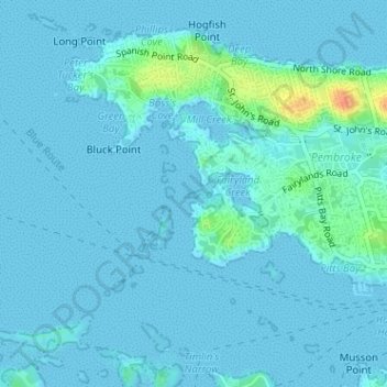
Name: Goat Island topographic map, elevation, terrain.

Location: Goat Island, Bermuda (32.29607 -64.80771 32.29669 -64.80606)

Average elevation: 5 m

Minimum elevation: -1 m

Maximum elevation: 43 m

Other topographic maps

Click on a map to view its topography, its elevation and its terrain.

Daniel's Head

Bermuda > Somerset

Daniel's Head, Somerset, MA 03, Bermuda

Average elevation: 3 m

Stokes Point

Bermuda

Stokes Point, GE 02, Bermuda

Average elevation: 5 m

Bermuda

Bermuda

Bermuda, Devonshire, DV04, Bermuda

Average elevation: 0 m

Pembroke

Bermuda

Pembroke, Bermuda

Average elevation: 7 m

Long Island

Bermuda

Long Island, Bermuda

Average elevation: 1 m