
Make a donation
Ashburton topographic map
Click on the map to display elevation.
Make a donation
Ashburton
On the whole, Ashburton shares a similar climate to Christchurch i.e. a dry temperate climate (Cfb). However, since it lies further inland at a higher altitude to Christchurch, Ashburton experiences a greater range of temperatures. During summer Ashburton can exceed 30 °C (86 °F), whilst winter can see regular frosts and annual snowfall. Ashburton's heaviest snowfall was 38 centimetres (15 in) on 12 June 2006, conversely it is tied with Timaru for New Zealand's fourth-highest temperature on record, reaching 41.3 °C (106.3 °F) on 7 February 1973.
Make a donation
About this map
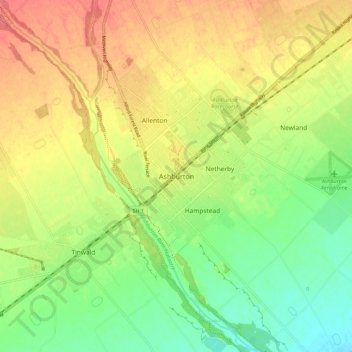
Name: Ashburton topographic map, elevation, terrain.
Average elevation: 99 m
Minimum elevation: 67 m
Maximum elevation: 132 m
Ashburton District trails, hiking, mountain biking, running and outdoor activities
Make a donation
Other topographic maps
Click on a map to view its topography, its elevation and its terrain.
Methven
New Zealand > Canterbury > Ashburton District
Methven is a small town in the Canterbury region of the South Island of New Zealand. It is located near the western edge of the Canterbury Plains, 34 km (21 mi) north of Ashburton and 95 km (59 mi) west of Christchurch, and at an elevation of 320 m (1,050 ft). The town is a service centre for agriculture in…
Average elevation: 321 m
Make a donation