
Atlantic County topographic map
Interactive map
Click on the map to display elevation.
About this map
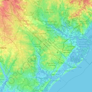
Name: Atlantic County topographic map, elevation, terrain.
Location: Atlantic County, New Jersey, United States (39.26205 -74.98522 39.72991 -74.23182)
Average elevation: 15 m
Minimum elevation: -4 m
Maximum elevation: 64 m
The county lies along the Atlantic Coastal Plain, with sea level and the Atlantic Ocean to the east. Adjacent to the coast are three barrier islands – Absecon Island (Which contains Atlantic City, Ventnor, Margate, and Longport), Brigantine Island, and Little Beach. To the west of the barrier islands, 4 mi (6 km) stretch of marshlands, inlets, and waterways connect and form the Intracoastal Waterway. Beneath the county is a mile of clay and sand that contains the Kirkwood–Cohansey aquifer, which supplies fresh groundwater for all of the streams and rivers in the region. The interior of the county is part of the Pine Barrens, which covers the southern third of New Jersey, and is prone to forest fires. Lowland areas are swampy and contain pitch pine or white cedar trees. Upland areas in the west of the county are hilly, containing oak and pine trees. The highest elevation in the county – about 150 ft (46 m) above sea level – is found near the border with Camden County, just west of Hammonton. The county's western boundary with Burlington and Camden counties, clarified in 1761, is a manmade line about halfway between the Atlantic Ocean and the Delaware Bay.
Other topographic maps
Click on a map to view its topography, its elevation and its terrain.
Spotswood
United States > New Jersey > Middlesex County
Spotswood, Middlesex County, New Jersey, 08884, United States
Average elevation: 15 m
Princeton
United States > New Jersey > Mercer County
Princeton, Mercer County, New Jersey, United States
Average elevation: 45 m
Jersey City
United States > New Jersey > Hudson County
Jersey City, Hudson County, New Jersey, United States
Average elevation: 9 m
Camden
United States > New Jersey > Camden County
Camden, Camden County, New Jersey, United States
Average elevation: 7 m
Clark
United States > New Jersey > Union County
Clark, Union County, New Jersey, United States
Average elevation: 23 m
National Park
United States > New Jersey > Gloucester County
National Park, Gloucester County, New Jersey, 08063, United States
Average elevation: 3 m
Township of Washington
United States > New Jersey > Bergen County > Township of Washington
Township of Washington, Bergen County, New Jersey, 07676, United States
Average elevation: 37 m
Park Ridge
United States > New Jersey > Bergen County
Park Ridge, Bergen County, New Jersey, 07656, United States
Average elevation: 67 m
Point Pleasant
United States > New Jersey > Ocean County > Point Pleasant
Point Pleasant, Ocean County, New Jersey, 08742, United States
Average elevation: 3 m
Bay Head
United States > New Jersey > Ocean County > Bay Head
Bay Head, Ocean County, New Jersey, United States
Average elevation: 2 m
Manasquan
United States > New Jersey > Monmouth County > Manasquan
Manasquan, Monmouth County, New Jersey, United States
Average elevation: 7 m
Nutley
United States > New Jersey > Essex County > Nutley
Nutley, Essex County, New Jersey, 07110, United States
Average elevation: 37 m
Rutherford
United States > New Jersey > Bergen County > Rutherford
Rutherford, Bergen County, New Jersey, 07070, United States
Average elevation: 13 m
Rosedale
United States > New Jersey > Mercer County > Lawrence Township > Rosedale
Rosedale, Lawrence Township, Mercer County, New Jersey, 08541, United States
Average elevation: 57 m
Newark
United States > New Jersey > Essex County > Newark
Newark, Essex County, New Jersey, 07102, United States
Average elevation: 37 m
Beach Creek
United States > New Jersey > Cape May County > Ocean City
Beach Creek, Ocean City, Cape May County, New Jersey, 08248, United States
Average elevation: 1 m
Mount Laurel
United States > New Jersey > Mount Laurel
Mount Laurel, Mount Laurel Township, Burlington County, New Jersey, 08053-5510, United States
Average elevation: 18 m
Maplewood
United States > New Jersey > Maplewood
Maplewood, Essex County, New Jersey, 07040, United States
Average elevation: 85 m
Livingston
United States > New Jersey > Livingston
Livingston, Essex County, New Jersey, 07039, United States
Average elevation: 104 m
Cookstown
United States > New Jersey > Cookstown
Cookstown, New Hanover Township, Burlington County, New Jersey, 08511, United States
Average elevation: 32 m
Beach Haven
United States > New Jersey > Ocean County
Beach Haven, Ocean County, New Jersey, United States
Average elevation: 1 m
Flemington
United States > New Jersey > Hunterdon County
Flemington, Hunterdon County, New Jersey, United States
Average elevation: 56 m