
Whau River topographic map
Interactive map
Click on the map to display elevation.
About this map
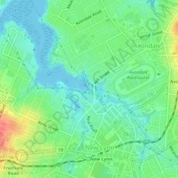
Name: Whau River topographic map, elevation, terrain.
Location: Whau River, New Lynn, Whau, Auckland, 0600, New Zealand (-36.90077 174.67857 -36.89861 174.68432)
Average elevation: 19 m
Minimum elevation: 0 m
Maximum elevation: 56 m
Other topographic maps
Click on a map to view its topography, its elevation and its terrain.
Whau River
New Zealand > Auckland > Whau
Whau River, Whau, Auckland, 0600, New Zealand
Average elevation: 17 m
Wairau Creek
New Zealand > Auckland > Whau
Wairau Creek, Kelston, Whau, Auckland, 0602, New Zealand
Average elevation: 20 m