
Santa Ana topographic map
Interactive map
Click on the map to display elevation.
About this map
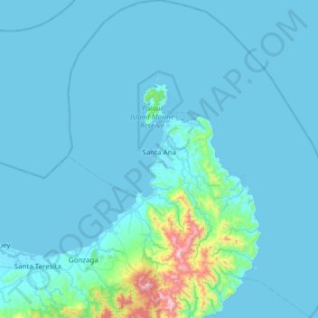
Name: Santa Ana topographic map, elevation, terrain.
Location: Santa Ana, Cagayan, Cagayan Valley, 3514, Philippines (18.15615 121.96679 18.73337 122.47812)
Average elevation: 67 m
Minimum elevation: -4 m
Maximum elevation: 1,124 m
Other topographic maps
Click on a map to view its topography, its elevation and its terrain.
Mount Camiguin
Philippines > Cagayan > Calayan
The well-forested Mount Camiguin or Camiguin de Babuyanes has an elevation of 712 metres (2,336 ft) asl, and a base diameter of 3,200 metres (10,500 ft). It occupies the southwest tip of 22 km (14 mi) long Camiguin Island.
Average elevation: 288 m