
Thank you for supporting this site ❤️
Make a donation
Make a donation
Epping Forest topographic map
Click on the map to display elevation.
Thank you for supporting this site ❤️
Make a donation
Make a donation
Epping Forest
The forest is approximately 19 kilometres (12 mi) long in the north-south direction, but no more than 4 kilometres (2.5 mi) from east to west at its widest point, and in most places considerably narrower. It lies on a ridge between the valleys of the rivers Lea and Roding. It contains areas of woodland, grassland, heath, rivers, bogs and ponds, and its elevation and thin gravelly soil (the result of glaciation) historically made it unsuitable for agriculture.
Thank you for supporting this site ❤️
Make a donation
Make a donation
About this map
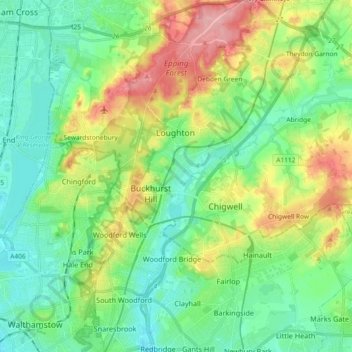
Name: Epping Forest topographic map, elevation, terrain.
Average elevation: 44 m
Minimum elevation: 7 m
Maximum elevation: 121 m
Thank you for supporting this site ❤️
Make a donation
Make a donation
Other topographic maps
Click on a map to view its topography, its elevation and its terrain.