
Combe topographic map
Interactive map
Click on the map to display elevation.
About this map
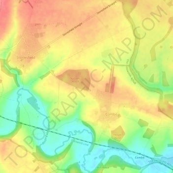
Name: Combe topographic map, elevation, terrain.
Average elevation: 106 m
Minimum elevation: 68 m
Maximum elevation: 135 m
Other topographic maps
Click on a map to view its topography, its elevation and its terrain.
Charlbury
United Kingdom > England > West Oxfordshire > Charlbury
Charlbury, West Oxfordshire, Oxfordshire, South East, England, OX7 3, United Kingdom
Average elevation: 138 m
Chipping Norton
United Kingdom > England > West Oxfordshire > Chipping Norton
Chipping Norton, West Oxfordshire, Oxfordshire, South East, England, OX7 5NA, United Kingdom
Average elevation: 184 m