
Bradford topographic map
Interactive map
Click on the map to display elevation.
About this map
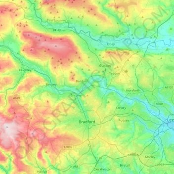
Name: Bradford topographic map, elevation, terrain.
Average elevation: 175 m
Minimum elevation: 28 m
Maximum elevation: 450 m
Bradford is located at 53°45′00″N 01°50′00″W / 53.75000°N 1.83333°W / 53.75000; -1.83333 (53.7500, -1.8333)1. Topographically, it is located in the eastern moorland region of the South Pennines.
Other topographic maps
Click on a map to view its topography, its elevation and its terrain.
Keighley
United Kingdom > England > Bradford > Long Lee
Keighley, Long Lee, Bradford, West Yorkshire, England, United Kingdom
Average elevation: 223 m
Queensbury
United Kingdom > England > Bradford
Queensbury, Bradford, West Yorkshire, England, BD13 2FR, United Kingdom
Average elevation: 284 m
Ilkley
United Kingdom > England > Bradford
Ilkley, Bradford, West Yorkshire, Yorkshire and the Humber, England, United Kingdom
Average elevation: 221 m