
Make a donation
South Waikato District topographic map
Click on the map to display elevation.
Make a donation
About this map
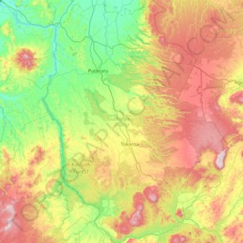
Name: South Waikato District topographic map, elevation, terrain.
Location: South Waikato District, Waikato, New Zealand (-38.43982 175.62214 -37.89135 176.15033)
Average elevation: 343 m
Minimum elevation: 35 m
Maximum elevation: 847 m
Waikato trails, hiking, mountain biking, running and outdoor activities
Make a donation
Other topographic maps
Click on a map to view its topography, its elevation and its terrain.
Make a donation
Make a donation
Make a donation
Make a donation
Make a donation
Make a donation
Make a donation
Make a donation
Make a donation
Make a donation
Make a donation
Make a donation
Make a donation
Make a donation
Make a donation
Make a donation
Make a donation
Make a donation
Make a donation
Matarangi Bluff
New Zealand > Waikato > Thames-Coromandel District > Rings Beach
Average elevation: 21 m
Make a donation
Rangiaowhia War Memorial Domain
New Zealand > Waikato > Waipa District > Kihikihi > Rangiaowhia
Average elevation: 69 m
Make a donation
Make a donation
Craters of the Moon
New Zealand > Waikato > Taupo District
Craters of the Moon is a steam field with a total of about 36 hectares (0.36 km2) of heated ground. It has an average altitude of 435 m. It has – of course – craters, but it also has fumaroles (“blowholes”) and a mudpool. Vegetation around the area of the Craters of the Moon is quite uncommon.
Average elevation: 441 m
Make a donation
Make a donation
Make a donation