
Taupō District topographic map
Interactive map
Click on the map to display elevation.
About this map
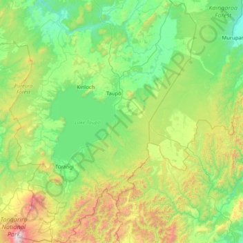
Name: Taupō District topographic map, elevation, terrain.
Location: Taupō District, Waikato, New Zealand (-39.30065 175.51835 -38.30103 176.69771)
Average elevation: 659 m
Minimum elevation: 132 m
Maximum elevation: 2,739 m
Waikato trails, hiking, mountain biking, running and outdoor activities
Other topographic maps
Click on a map to view its topography, its elevation and its terrain.
Craters of the Moon
New Zealand > Waikato > Taupo District
Craters of the Moon is a steam field with a total of about 36 hectares (0.36 km2) of heated ground. It has an average altitude of 435 m. It has – of course – craters, but it also has fumaroles (“blowholes”) and a mudpool. Vegetation around the area of the Craters of the Moon is quite uncommon.
Average elevation: 441 m